By Jerry Smith
Rock Junction 2013 began early Wednesday morning at the City
Market on Orchard Mesa. After the customary signing of the documents and safety
spiel, trip leader Jerry Smith led off for adventure.

Turning onto Highway 141, we began the trip through Unaweep
Canyon. This route is a state “Scenic
Byway” for a good reason. Some of the history, geology, and just pure scenic
pleasure of driving toward Gateway, Colorado is simply mesmerizing.
As you change altitude, the scenery goes from one of high
desert canyon country into one where near vertical walls of granite rock keep
you wondering how such beauty could be created.
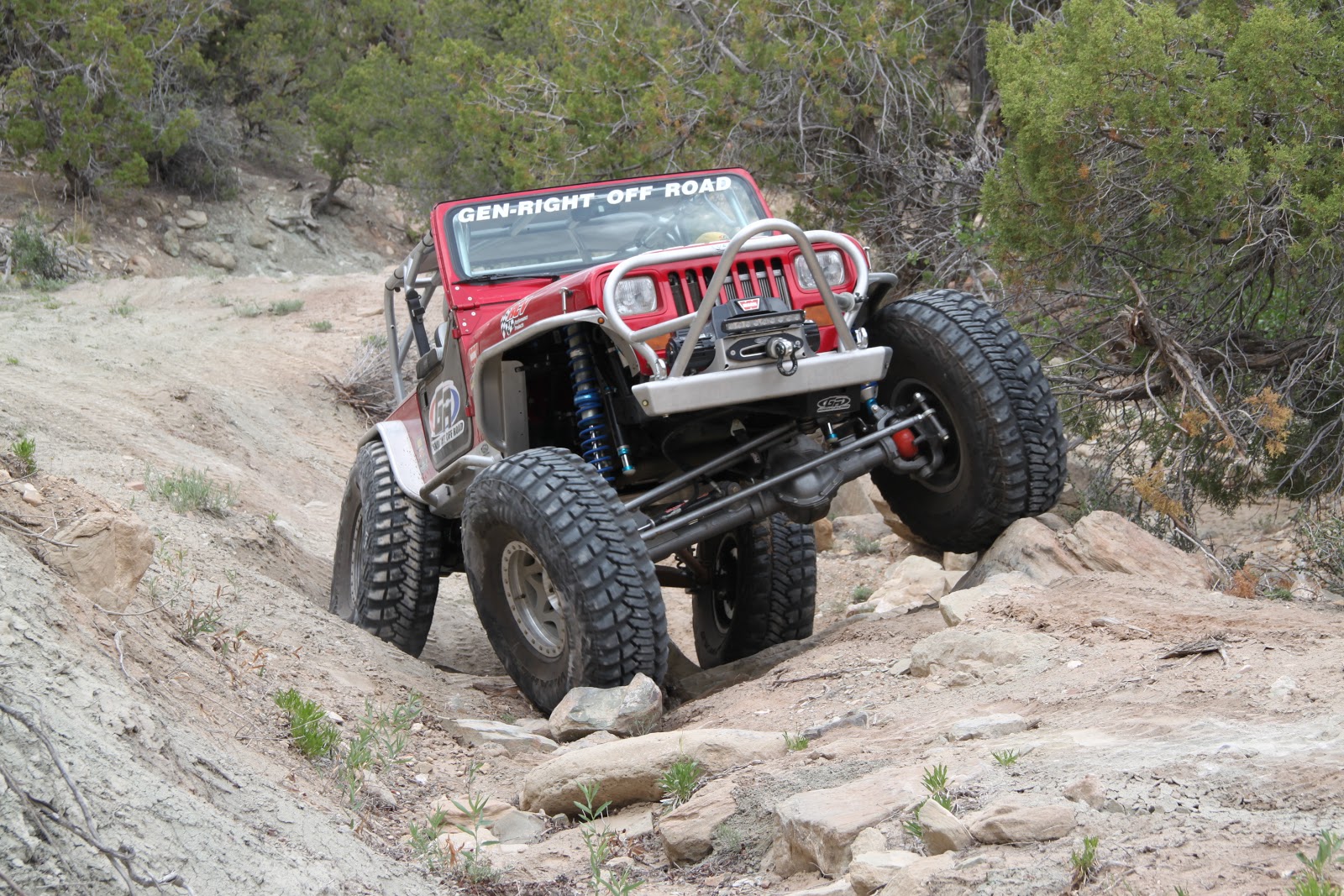
Reaching the 6.3 Road turnoff, we stopped to aired down in
preparation for the long climb up what is locally known as the “Niche Road”.
The first roughly 8 miles of this climb averages a 15% grade and frequently
requires one rig or another to stop for a cool-down. Tim's Cherokee required one short such
period.
 |
| Airing down with the Palisade WSA in the background. |
Having rained the night before, we encountered little dust
on the freshly bladed road. The rain had cleansed the air to near pristine quality
making the views stunning, but had raised the possibility of problems further
along the trail.
 |
| Crawling up the "Niche Road" affords you some spectacular views. |
The Calamity Mesa Loop as several sections that pass through
bentonite. Wet bentonite can be nearly impossible to traverse in any vehicle,
and we were going to be crossing at least one significant bentonite obstacle
that is tough enough without being wet. If wet enough, it would be insane to
even try it.
After turning onto upper Calamity Mesa, we headed southwest
toward Arrowhead Camp where a yellow 4X8 sign warns that you are entering
Uranium Country with all of its hazards. This intersection is the beginning and
ending of the Calamity Mesa Loop.
The Calamity Mesa Loop is approximately 20 miles of 4 x 4
heaven. After an estimated 10 to 15 years of closure by Mother Nature, members
of the Grand Mesa Jeep Club and Western Slope Four Wheelers of Montrose,
Colorado, reopened this trail in 2008.
We know it was closed this long because of one particular
pine tree that had grown in the middle of the road. This tree had to be cut
down to get around it. The stump was approximately 4 to 5 inches in diameter.
 |
| This tree stump gives you an idea of how long Mother Nature's closure lasted. |
Since then, members of the Grand Mesa Jeep Club have
maintained it every year. Nearly every year many new rocks, trees, and washes
must be removed or filled in to keep the trail open.
Approximately 1/2 of the Calamity Mesa Loop is a Mesa County
Road. It is either the best or the worst County Road you’ll ever drive
depending upon your particular outlook.
Our first stop was at the New Verde Mine site. There, an old
workshop with a three-cylinder diesel engine and air compressor gives a little
view back into the history of uranium mining. A couple of years ago, the roof
above the air compressor finally collapsed from the weight of the winter
snowfall.
 |
| The shop at the New Verde Mine still stands (though barely). |
Jerry told about how volunteers, under the supervision of
the BLM and the Museum of Western Colorado, had rebuilt several of the cabins of
Calamity Camp across a small ravine.
Continuing on down the road from the New Verde Mine, most of
us dropped into low range as the surface of the road changed character. We
passed several intersections with roads leading to other mine sites and up onto
the mesa top.
Jerry explained to the others that there was an alternative
road on the mesa top that could lead us around the first three named obstacles
if the bentonite seemed too wet further on.
The Calamity Mesa Loop presently has 11 named obstacles.
There are plenty of other unnamed obstacles, but these 11 have proven to be of
outstanding consequence.
The first named obstacle is “The Gatekeeper”.
 |
| Happy Trails in "The Gate Keeper Wash" |
Here, a wash has taken the right side of the road and left a
deep, rocky, and difficult descent for about 60 yards. At the end of the 60 yards, one must regain
the road by way of a severe off camber climb. This puts you directly onto the next aimed
obstacle, “The Narrows”.
“The Narrows” is a long stretch of road across a bentonite
hillside and a continuation of the wash that created the gatekeeper. The wash
has cut a deep, steep sided gouge on the north side of the road. If you slide
off into this gouge, you will roll onto your side.
 |
| "The Narrows" doesn't leave much room for error. |
On the other side of the road is a steep bentonite hillside.
What's left of the road surface is a very narrow, severely crowned trail with
an occasional large rock that one must evade without going off the side of the
road. Luckily, the bentonite surface was dry enough to allow us access to the
rest of the trail.
A little further on we encountered “Gyration Wash”. “Gyration Wash” is where winter runoff has
cut across the road surface multiple times causing your suspension to gyrate
from one side to the other as you enter a small cut through a ridge.
 |
| Even with 42" tires, you can have some fun on The Calamity Mesa Loop |
At the lower end of this obstacle is a rocky drop where you
must pick the correct line or you can get precariously off camber at a very bad
time. Some of the rocks will reach up to destroy your rocker panel if you take
a poor line.
The next several miles of the trail do not contain any more
of the named obstacles, but there are enough rough spots to provide you with
some lesser challenges. Beside the challenges, you also have to deal with some
outstanding backcountry scenery.
Across the Calamity Creek Valley is Outlaw Mesa where more
uranium mines and several 4 x 4 roads exist. Further south is Blue Mesa that
gets its name from the blue hue of bentonite along its flanks.
At the confluence of Calamity Creek and Blue Creek, is the
Blue Creek Ranch. The Blue Creek Ranch is one of several properties in the
Gateway area owned by John Hendricks… founder and chairman of the Discovery
Channel and Animal Planet.
After taking the right fork where the road splits that will
take you down to the Blue Creek Ranch, we proceeded to what has become “The
Lunch Spot”.
“The Lunch Spot” is a favorite of most who have had the
privilege of driving the Calamity Mesa Loop.
At “The Lunch Spot”, you can dine while setting on the rim
of a 400-foot vertical cliff with a bench that reaches over to the Blue Creek
Gorge. The Blue Creek Gorge is a narrow, vertical walled canyon approximately
600 feet deep that dumps into the Dolores River.
 |
| The confluence of Blue Cr. Gorge and the Delores River. |
The Dolores River divides Calamity Mesa from Sewemup Mesa to
the west of the river. Sewemup Mesa is a Wilderness Study Area.
To the west of Sewemup Mesa is the Sinbad Valley and beyond
you can see the very tops of the La Sal Mountains near Moab, Utah. The view is
simply awesome.
Sewemup (pronounced: Sew-em-up) Mesa got its name from
cattle rustlers who would take their ill-gotten cattle into Sinbad Valley where
they would surgically remove the brands and sew up the wound. Later, they would
rebrand the cattle. (Anyone need a
tattoo removed?)
The McCarty Gang also used Sinbad Valley as a hideout. The
McCarty Gang were friends and accomplices of Butch Cassidy and the Sundance Kid.
 |
| Leaving the "Lunch Spot" will quickly settle your lunch. |
After allowing our lunches to settle, we began a short, very
rocky climb. From here the trail begins a climb that parallels the Dolores
River before turning east along the Little Tenderfoot Creek Valley.
Much of this stretch of road is along a lower rim of
Calamity Mesa. Many who drive this stretch do not particularly like it because
you must negotiate your way along a steep mountainside where the road is quite
narrow and full of rocks you must either crawl over or around.
 |
| Levi getting wound-up on "Twisted Drop". |
Crawling over the rocks tilts your vehicle up for a much
clearer view over the side of the mountain. Going around the rocks puts your
tires dangerously near the edge of the road leaving little room for comfort.
Some passengers elect to walk along here.
 |
| Near the edge is where the view is best. |
Soon we come to “Mike’s Rock”. This obstacle looks very benign as you
approach it. It is sneaky that way. There is a large rock on the outside of the
road with a less than Jeep’s width of flat road surface over to smaller rocks
that protrude from under a bush.
Most people choose a line much too near the large rock and
as the passenger side tires climb the smaller rocks, their vehicle tilts into
the larger rock. The first two times Mike attempted this obstacle, he put the
first two scratches on his 2007 Rubicon, thus the name “Mike’s Rock”.
 |
| Mike on "Mike's Rock" |
Several times we have found bear tracks at “Mike’s
Rock”. It is common to see deer and elk
tracks anywhere along this trail. Occasionally, you will see bear and/or
mountain lion tracks as well. Unfortunately, this trip we saw none.
The next named obstacle is “Articulation Station”. Here you must dive left off of the road into
a deep wash that cuts across the road. Immediately as you hit the bottom of the
wash you must turn right bringing you into a severe off camber.
 |
| "Articulation Station" will test your suspension. |
From there, you need to climb up and over large rocks that
roll under your tires and differentials making the climb out of the hole quite
difficult. Your suspension will get a very good workout.
Once you climb out of the hole, you are on the next obstacle…
called “Hog Back”.
“Hog Back” is a narrow, very crowned piece of road with
large rocks protruding from its surface. The correct line is necessary to keep
from becoming “turtled” or high centered on several of the protruding rocks.
Often, this results in one or both differentials being grounded.
From here you are only a short S turn away from “Drop Off
Turn”.
 |
| Tim rounding "Drop-Off Turn" |
“Drop off Turn” is where a large rock on your left side
reaches out to either cut your rear tire sidewall or rip that tire from the
bead. On the other side, your front tire must drop off of a large rock that
often causes your axle to ground on that rock. It often causes a ghastly noise
when this happens.
Tony Pellegrino from GenRight was the last to go around
“Drop Off Turn” on this trip. His 42-inch tires actually moved part of the rock
on the driver side, so we will have a whole new obstacle for the next trip.
After a little more scenic driving, we come to “Over-Night
Wash”. This obstacle gets its name from causing an unplanned overnight stay for
the three vehicles that came through here the first time.
 |
| "Over Night Wash" is narrow and dangerous at times. |
This wash cuts across the road and takes an immediate left
to parallel the road. As it parallels the road, it has removed much of the road
bank and narrowed the road to barely allow vehicle passage. This leaves a
dangerous five or six-foot vertical drop into the wash.
Many times on our pre-runs for Rock Junction, it has been
necessary to find and winch large rocks into this wash to allow safe passage.
About 3/8 of a mile later, we come to “Tippy Rock”. It gets its name from the fact that most
vehicles must climb the high side of the road while going around a large rock
in the middle of the road.
 |
| Bob on "Tippy Rock" |
Climbing the high side of the road puts you and a severe off
camber, thus the “Tippy”. Many of us with very high clearances have found that
going up and over the rock is much more fun.
The last of the named obstacles is “The Squeeze”. This is why we do not allow full width
vehicles on this trail. Here, you must squeeze between a Juniper tree growing
on the rim of the road and a large rock in the middle of the road. This leaves
barely micro inches between your vehicle and the rock or tree and we'd
recommend you do it at less than 25 mph.
 |
| Bob showing why no full-size vehicles are allowed on the Calamity Mesa Loop. |
From here the road for the most part becomes relatively easy.
It climbs back up on to the upper part of Calamity Mesa and back to the big
yellow sign.
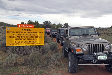 |
| Warning! Uranium Mining can be dangerous. |
Between the ambient temperature, the pristine air quality,
and the fine group of four wheelers, this day had very little room for
improvement. Everyone seem to agree that the trail and the surrounding area had
given their all for our enjoyment.
Just a side note; A major thank you to Wendy Barton for
riding with me and taking the majority of photos for all to enjoy. This freed me up to assist the others who
needed it and kept us on schedule to make it to the BBQ on time. (this is the first year we made it on time)
As always, we close with a last thought; when you come to a
fork in the road… Take it! That is often where the adventure begins.
Copyright Happy Trails 4wd, 2013. All rights reserved.